Collection Name
Collection Name
About
About
Photographs of flood damage
Media Items
Media Items
Media Items
ItemID
acfl051
IDEntry
7387
Creator
Nelson Hause
Date
1936
Collection Location
Western Maryland Room, Washington County Free Library
Coverage
Western Maryland, 1936
Body
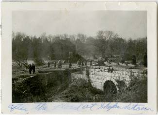
This view is of lock 38 at Bridgeport, across from Shepherdstown. On the far bank is Bellevue. There is a boat on top of the flume. The bridge between West Virginal and Maryland was washed away in this flood and was not rebuilt until 1939.
Unrau wrote: The canal at Shepherdstown was inundated for 62 hours, and at its peak the flood reached an elevation of 22 feet above the towpath, a height exceeding the 1889 figure by five feet.
Notes
This photograph was among a collection given to the Western Maryland Room by Nelson Hause's family.
See: Unrau, H. D., & Gray, K. M. (2007). Historic resource study: Chesapeake & Ohio Canal. Hagerstown, Md: U.S. Dept. of Interior, National Park Service, Chesapeake & Ohio Canal National Historical Park.