Collection Name
About
Media Items
Negro Mountain: New Insight on Name
The following information appeared in a newspaper article appearing in the July 24, 2016 edition of the Cumberland Times-News. It was written by Champ Zumbrun with input from Nina Higgins, historian for the Cresap Society. The information is excerpted from four articles written in 1756 and recently discovered in two colonial newspapers from that era, these being the Maryland Gazette and the Pennsylvania Gazette. It tells of an incident that occurred at the time of the French and Indian War. Thomas Cresap Jr. had been killed during an encounter with Indians on April 23, 1756 about 15 miles west of Fort Cumberland. One month later his father, Colonel Thomas Cresap, left Fort Cumberland to complete his son’s mission, this being the removal of Indian threats to the region. It is written a black frontiersman marched with Cresap. He was “old” and of “gigantic stature,” and had volunteered to fight for the English against the French and Indians. Though no name is given, he was identified as a “free Negro.” The following Cumberland Times-News article excerpt tells the tale:
“On May 28, 1756 at sunset, the incident that resulted in the naming of the mountain began. It started when Cresap heard an ‘Indian holler,’ and looking ahead, saw two Indians riding on horses towards him. Instead of taking cover, Cresap marched toward them on the road, in his words, ‘with my gun cocked on my shoulder.’ A ‘running fight’ had begun.
Cresap temporarily lost sight of the Indians due to a bend in the road. About the same time the Indians came back into view, the black frontiersman suddenly appeared in support of Cresap. Standing on the road just 30 yards from Cresap, the brave black frontiersman ‘presented his gun’ at the two Indians. The Indians at this time ‘immediately alighted from their horses.’
Another Indian appeared and the three Indians soon took cover behind trees, two on one side of the road and the other on the opposite side. Cresap and the black frontiersman were caught standing on the road without cover, ‘not having advantage of any tree at that place.’
The courageous actions of the black frontiersman drew the attention of the Indians to himself and away from Cresap. Within seconds ‘two of the Indians fired and shot the Negro,’ killing him. The bold behavior of the black frontiersman allowed time for four of Cresap’s men to return fire, killing one Indian, wounding another, and causing the other to flee.”
Thomas Cresap’s life had been saved. And according to John J. Jacob’s 1826 Cresap biography entitled, “Life of the Late Captain Michael Cresap,” it was this incident which resulted in the naming of “Negro Mountain.”
Additional research on this subject by historian Champ Zumbrun indicates that Nemesis was a “free Negro,” and that the name "Nemesis" itself did not appear in writings until after over 120 years from the 1756 event on the mountain. Based upon even further research by Champ Zumbrun, the name “Negro Mountain” first appears on maps dating as far back as 1822. Additional maps bearing this name appeared in 1826, 1834, 1836, 1838, 1873 and 1876. The links are below.
Zumbrun’s research further states that John Jacob’s history of Michael Cresap published in 1826 confirms the mountain is named Negro Mountain as a result of the 1756 incident. Jacob had married the widow of Michael Cresap who was at the incident in 1756 that resulted in the naming of the mountain.
1822, Melish, John - Map of Pennsylvania : constructed from the county surveys authorized by the state and other original documents
1826, Melish, John - Map of Pennsylvania, constructed from the county surveys authorized by the State; and other original documents by John Melish
1836, Lucas, Fielding Jr - Maryland, Delaware, and Parts Of Pennsylvania & Virginia
1838, Bradford, Thomas G. - Maryland
1873, Gray, O.W. - Delaware and Maryland.
1876, Gray, Frank A. and Gray, O.W. - Maryland, Delaware and the District of Columbia.
And finally and perhaps most importantly, this research by Scott Williams:
“The oldest reference to the place name “Negro Mountain” was found in The Journal of Nicholas Cresswell, 1774-1777. Nicholas Cresswell (1750–1804) was an Englishman from Derbyshire who left his farming community for the North American colonies at the age of 24. Cresswell was a diligent diarist and his notes on three years of travel in the Middle Atlantic colonies at the beginning of the Revolutionary War have provided a wealth of material for historians. His diary entries from April 1775 trace his travels from the Potomac Valley to the Ohio River including a recitation of each ridge that he crosses. In both his westward journey and his return to the Potomac Valley in October 1775 he cites 'Negro Mountain' as a landmark – an indication that the mountain was known by its current name just 19 years after the events of 1756. - The journal of Nicholas Cresswell, 1774-1777
Negro Mountain also appears as a place name in a 1786 Bedford County property tax roll for Turkey Foot Township published in the Freeman Journal 6. The construction of the National Road on Negro Mountain is reflected in a table of distances published in the Maryland Gazette in 1807.”
Local historian Dave Williams also noted a reference to the ridge being known as "Negro Mountain" in an article, "A Quaker Pilgrimage; Being a Mission to the Indians from the Indian Committee of the Baltimore Yearly Meeting, to Fort Wayne, 1804"; William H. Love; Maryland Historical Magazine, Vol. IV, No. 1, March 1909. pg. 5.
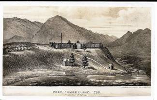
Photograph: The Fort Cumberland postcard, from a lithograph by the A. Hoen Lithography Company of Baltimore, originally appeared in William Harrison Lowdermilk's History of Cumberland, Maryland published in 1878. It was later made into a postcard and published in the early 1930's by C.E. Gerkins, 81 N. Centre Street, Cumberland, Maryland. The postcard is from the collection of Angela and Albert Feldstein.