Collection Name
About
Media Items
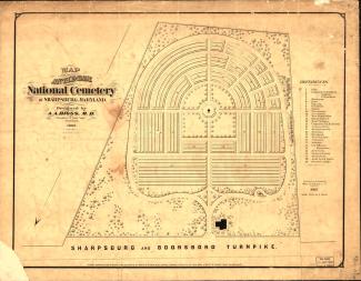
Map of Antietam National Cemetery as designed by A. A. Biggs, M. D., President & Genl. Supt., Sharpsburg, 1866.
"Entered according to Act of Congress in the year 1867 by the Board of Trustees of the 'Antietam National Cemetery' in the Clerks Office of the U.S. District Court for Maryland."
-- The map reflects the information in this list of location of sections and grave numbers with the exception of Wisconsin. The list puts Wisconsin in Section 15, the map Section 10.
-- The map includes Lee's Rock, the rock that legend has it Robert E. Lee stood on to survey the battle. It was a provocative feature and controversy raged as to whether "a relic of rebellion ought to stand amid the graves of the Union dead" (Henry Kyd Douglas). It was eventually removed. (It is in lower right quadrant, labeled 28. The carriage way/path went around the rock.)
Click image to Zoom in on clearer map.
Augustin A. Biggs was a physician in Sharpsburg at the time of the Civil War. He was one of the original trustees from Maryland named in the charter of the cemetery and the first president of the Board of Trustees. He was appointed General Superintendent of the cemetery in order to start work on interring those Union soldiers killed in Maryland.