Collection Name
About
Media Items
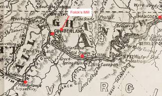
This map, based on an 1875 map of Allegany County, marks in red the towns of Hancock, Cumberland, Old Town (along the C&O Canal and the Potomac River) and Paddy Town.
Keyser was originally called Paddy Town after Patrick McCarty, son of one of the original settlers. With the coming of the Baltimore and Ohio Railroad in 1852, the name was changed to New Creek Station and then to New Creek. In 1861 the Civil War came rumbling through the valley. Fort Fuller was built on the present site of Potomac State College, and Fort Piano entrenchments were established on New Creek Mountain. In 1874, the town was incorporated as Keyser to honor William Keyser, Vice President of the Baltimore and Ohio Railroad.
Folck's Mill, also known as Pleasant Mill, was located on Evitt's Creek near Elk Run near the road between Hancock and Cumberland. The remains of the mill are across Route 68 from the Ali Ghan Shrine, two miles east of Cumberland.
Based on a Map of Maryland, Delaware, and the District of Columbia (Washington D.C.) by John F. Weishampel, Jr., a Baltimore bookseller and stationer, 1875.