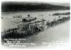
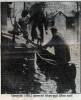
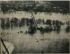
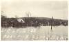
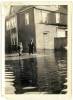
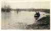
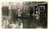
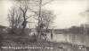
Conococheague flooding at Williamsport, 1936
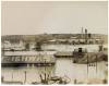
The old power plant and the Cushwa warehouse, now by the Cushwa basin on the C&O canal. Between the power plant and the tannery with its towers is the Conococheague Creek.
Hagerstown Pumping Plant above Williamsport, Maryland
Kelly's Studio and Camera Shop, Hagerstown Md.
3-19-1936
Made with Fairchild Aerial Camera
A-3
Hancock (Md.) canoeist takes pair from roof.
United States Army in World War II U.S. Army Center of Military History
Views Of Flood Which Swept Potomac River Valley
This aerial photographs show the effects of Potomac waters in the vicinity of Hancock. The photograph shows a general view of the town where many homes were vacated by residents. Picture were taken from a National Guard plane piloted by Lieut. P. DeBrutz Jacques, of Washington county.
Published in the Hagerstown Morning Herald.
Views Of Flood Which Swept Potomac River Valley
An aerial photograph showing the effects of Potomac waters in the vicinity of Hancock. A view of Hancock and the highway bridge which was later swept out by the surging waters. Photograph taken from a National Guard plane piloted by Lieut. P. DeBrutz Jacques, of Washington county.
Published in the Morning Herald, Hagerstown, March 20, 1936
The westside of Hancock was extensively flooded in the flood of 1936
Main Street, Hancock, near the intersection of Pennsylvania Avenue, March 1936
Marian Golden reported that her father, the photographer, told her that the 1936 flood was higher, more rapid, more intense that the 1985 flood. He said it was cleaner, in the sense there was only mud left behind, rather than the oily, polluted garbage that later floods have brought.
East end of Hancock, after the 1936 flood. Notice the telephone pole in the water.
Marian Golden remembered her father reporting that the majority of the flooding was in the west end of town. Only "Ice Hollow", the site of Hardee's today, was flooded in the east end.
The boat is being rowed down Main Street in Hancock, passed Dr. M.H. Cohen's dentist office and the sign in the water for Southern Dairies Icecream.
This annotated photograph shows the effect of the 1936 flood on the bridge crossing the Potomac River at Hancock. The high water mark on the bridge is marked where the span was washed away. A collection of leaves wedged at high water level in a tree is also marked.