Collection Name
About
Media Items
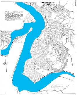
This map was included in the Shoppers Guide, a Souvenir History of Cumberland's Flood
CUMBERLAND SHOPPERS GUIDE
The coloring was added by James Rada for a talk Saturday, March 19 at the symposium held at the Allegany Museum on the 1936 St. Patrick’s Day Flood.
The original map had the legend:
The area included within the dotted lines in the section that was under water both in 1924 and 1936. Although the 1936 flood was 25 or more percent worse, the difference lay in the depth of water and the speed of the current rather than in the area covered.
Official Red Cross estimates placed the homeless as a result of the flood at 1200 families or 6000 individuals.
Map was furnished through the courtesy of Henry W. Schaidt, City Engineer.
---
Mr. Rada's addition of color makes the extent of the flooding much easier to see.