Collection Name
Collection Name
About
About
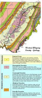
Map of mining in George's Creek
Media Items
Media Items
Media Items
ItemID
acgc015
IDEntry
1009
Creator
Maryland Geological Survey
Rights
Maryland Geological Survey
Date
1968
Collection Location
Maryland Geological Survey
Original size
35 cms x 28 cms
Coverage
Allegany County, MD; 1880-1940
Body
This map from the 1968 Maryland Geological Survey shows the location of coal in the George's Creek valley, from Frostburg to Westernport, with Lonaconing roughly halfway between the two towns. The purple color labeled PM is the Monongahela Formation, containing coal. The Maryland Geological Survey webpage has additional information:
http://www.mgs.md.gov/esic/geo/allw.html