Collection Name
Collection Name
About
About
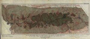
Map of mining in George's Creek
Media Items
Media Items
Media Items
ItemID
acgc055
IDEntry
2636
Creator
Maryland Geological Survey
Date
1903
Collection Location
Washington County Free Library
Contributor
Mining Properties by B. S. Randolph, Geology by G. C. Martin
Original size
26 cms x 60 cms
Coverage
Allegany County, MD; 1880-1940
Body
Map of Georges Creek Coal Basin showing the location of mining properties and the areal extent of the Pittsburg ("Big Vein") and Lower Coals.
Maryland Geological Survey,
Wm. Bullock Clark, State Geologist
1903.
Mining Properties by B. S. Randolph
Geology by G. C. Martin
Typology by the Maryland Geological Survey in cooperation with the U. S. Geological Survey
Notes
The map was donated to Washington County Free Library by the Library, Frostburg State University.