Collection Name
About
Media Items
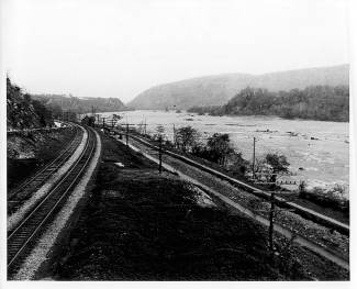
This picture was taken looking downstream at Sandy Hook. The mountain ridge to the right is Short Hill Mountain in Virginia. The road on the left leads from Weverton to Harpers Ferry. To the left of the road is Maryland Heights. (The modern Route 340 bridge from Maryland to Virginia would cross through the center of the image. )
The photograph shows the proximity in which the railroad and the canal were built. The road as well as the railroad and canal had to get through the narrows near Weverton and Harpers Ferry. The water is really low which could be attributed to drought or that section of the canal could have been drained for repairs to the canal prism.
The lockhouse at Lock 32 can be seen where the road and rails disappear.
Thompson 55