Collection Name
Collection Name
About
About
Floods and canal repairs
Media Items
Media Items
Media Items
ItemID
wcco008
IDEntry
5738
Rights
Public domain
Date
Unknown
Collection Location
C&O National Historic Park
Coverage
Maryland, 1824-1938
Body
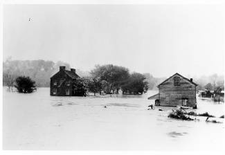
This picture most likely records the 1924 flood that resulted in the closure of the C&O Canal. The building on the right was a store that sold feed and likely also other supplies, while the lockhouse that stood between the towpath and the river is on the left. That lockhouse often flooded, but survived until finally being destroyed by the 1936 flood.
When the engineers designed the line of the canal they attempted to keep it as high and as far from the river as possible. Largely because of the adjacent high land, the canal along this part of the river follows the river bank for nearly twelve miles to Dam 4, making it highly vulnerable to floods.
Notes
Mile 72.8
NPS File 952