Collection Name
About
Media Items
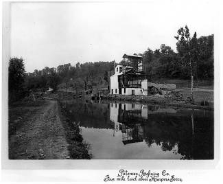
Potomac Refining Company Mine
The property belonging to the Potomac Refining Company is situated on the north bank of the Potomac River, three miles north of Harpers Ferry. At this place, a sharp bend in the river makes a projecting point on the north bank. A fault cutting across this point brings the Shenandoah limestone on the west down into contact with the Harpers shale on the east. It is along this fault plane that the ore occurs. It consists both of manganese and of iron ore. But up to the present only the manganese has been worked and the location on the map gives the manganese deposit.
This deposit was opened up in 1876 by Wells and Davis. They obtained both hard and soft manganese ore, which was shipped on the Chesapeake and Ohio Canal. The openings went below the level of the Canal, and the flooding of the mines caused a suspension of operations. About ten years ago the property was again opened by a Mr. McIntosh, who sunk a 23-foot shaft about one hundred feet from the Canal. Work had only been carried on about a month, when the shaft was flooded and the property again abandoned. In the spring of 1908, Mr. E. R. Cooper, of Baltimore, took hold of the property; and later the Potomac Refining Company was organized. A system of pumps has been installed and a washer for washing the ore erected. The old openings have been cleaned out and considerable new work done. A 60-foot shaft has been sunk near the limestone, which is expected to open up the main ore body. An adit at a higher level, running east, passes through a pocket of manganese ore, and an extension of this adit for one hundred and fifty feet N. 12° E. shows a pink manganiferous clay. This last drift, in all probability, lies too far to the east of the limestone, and a cross-cut from it toward the limestone would be very likely to strike the ore through which the adit passes. Several hundred tons of ore have been mined and washed, but no shipment has as yet been made.
The manganese ore, which is pyrolusite, occurs in irregular shaped lumps, or "kidneys," varying up to six inches in their longest dimensions, in a matrix of yellow clay through which smaller lumps are disseminated. A sample collected by Dr. J. S. Grasty, showed the following analysis:
ANALYSIS OF MANGANESE ORE FROM POTOMAC REFINING COMPANY MINE.
Mn 22.59
Sio2 26.68
Fe 2.73
P .37
S .004
Within a half mile north of the manganese openings, several prospect holes have been put down, which show the presence of iron ore. Two samples taken from these by Dr. Grasty showed the following composition:
ANALYSES OF IRON ORE FROM THE POTOMAC REFINING COMPANY DEPOSIT.
Pe 41.8. 53.36
Sio2 31.35 5.33
Mn Trace Trace.
P .034 .026
S Trace 1.29
The showing made by these prospect holes is very favorable, and if the prospecting is carried further, workable bodies of iron ore will in all probability be located.
Text is from Report on the iron ores of Maryland, by Joseph Singlewald, Johns Hopkins Press, 1911, available in the Washington County Free Library.
Mile 65.2
NPS File 827