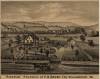
Residence of F.H. Darby
Media Items
Collection Name
About
Body
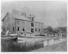
"River view"
Residence of F.H. Darby, Esq.
Williamsport, MD.
The 1880 census lists Frank H. Darby as a "grain merchant" in the Williamsport District.