
Washington County Maryland--History

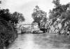
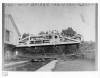
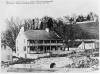
Lockhouse at Lock 49

Media Items
Body

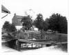
Photograph of the lockhouse at lock 49 where Sam Taylor lived from 1889-1924. Two different types of lock gate keys can be seen in the closed position on the lock gates. One style of the key is the bent handle key that is seen on three of the keys and the one that is to the far right hand side has a straight handle. A lock key is an iron bar that has a square bit that fits on the end of the bar that operates the paddle gates attached to the bottom of the lock gate. In order to control the level of water in the lock the paddle gates nearest the bottom of the lock would be opened.

Lock 47 and Drydock

Media Items
Body

Lock 47 is the first of the flight of locks, Nos. 47–50, that are in close proximity and around which a community grew known as Four Locks. Here the river makes a large bend around Prather’s Neck, which the canal cuts across. However, as the river falls considerably above this point, the canal needed to gain altitude before it cut across the neck to come out by the river upstream of the bend. A flight of locks allowed it to do.

Lockhouse, Guard Lock 5

Media Items
About
Body

This lock provides access to the pool behind Dam 5 which was used by canal boats for a distance of about half a mile until the canal resumed beyond a rocky cliff that had blocked it. These locks behind dams were often called “inlet locks” as well as “guard locks.” The term “inlet lock” emphasizes that they let water into the canal from the river and the term “guard lock” emphasized that they were built into a guard, allowing the canal to pass through it. Such guard walls extend from the dam abutment to the adjacent hillside.

Mule Bridge

Media Items
About
Body

This photograph shows a host of people who either lived or worked around the Two Locks area. They are standing on the mule crossover bridge that was used by the boatmen when the towpath switched from the berm side of the canal back over to the river side. The Newkirk & Steel store is visible on the left hand side. Tunis Newkirk also sold and rented mules to boatmen.

Lock 44 after the 1889 flood

Media Items
About
Body

LOCK 44 AFTER THE 1889 FLOOD
The 1889 flood broke records for previous floods in the historic period. The same storm that would breach a former canal dam in Pennsylvania to create the Johnstown flood, did enormous damage in the Potomac valley as well. The C&O Canal Company, unable to make the costly repairs, went into bankruptcy and in 1890 the bankruptcy court appointed receivers to repair and operate the canal. The canal would not reopen until September, 1891 and would be operated under the receivership until it closed permanently in 1924.

Lock 38 by G.D. Bast

Media Items
About
Body

This photograph must have been taken at some point after the 1889 flood as it shows only the piers for the second vehicle bridge that had been built in 1871 to replace the first bridge that had been destroyed in the Civil War. That bridge would be replaced with a third bridge that would survive until the 1936 flood. Largest of all floods in the Potomac Valley to date, the 1936 flood also took out the lockhouse seen here between the towpath and the river.

Lock 38 Area

Media Items
About
Body

This photograph provides an excellent view of the downstream end of a bypass flume that carried water past the lock. To keep the current as minimal as possible, canals are built on a series of levels with locks serving to raise and lower boats where the canal level is changed. However, it is still necessary to maintain a steady supply of water to all parts of the canal and the bypass flumes serve this purpose. Typically located on the berm side (i.e. land vs.