Allegany County Commissioners minutes, 3-23-1936
Media Items

Collection Name
Body
March 23, 1936.
March 23, 1936.
March 19, 1936.
At a special session of the Board of County Commissioners of Allegany County, held in their offices at the Court House on the above date, were present the following; President, A. Chas, Stewart, Commissioners, Nelson W. Russler and James Holmes, Attorney, David W. Sloan and Clerk Thos. P. Richards.
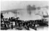
The meeting was called for the specific purpose of devising ways and means whereby the County Commissioners might extend their services in the emergency of the terrible flood which visited Cumberland and the adjacent territory.
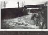
The flood affected areas in Maryland not only in the Potomac River basin. This photograph was taken in Cascade, Washington County, MD. The cascading water over the dam that you see under the Western Maryland Railway bridge is coming from Lake Royer on the Fort Ritchie Military Reservation, on South Mountain between Washington and Frederick Counties.
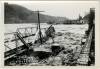
This Kelley photograph shows the destruction of the bridges in Harpers Ferry.
36½ feet – the all-time record crest at Harpers Ferry. The Bollman highway bridge and Shenandoah bridge were swept away for good, while many businesses in the Lower Town were left in ruins.
From Memorable Floods at Harpers Ferry.
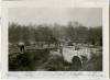
This view is of lock 38 at Bridgeport, across from Shepherdstown. On the far bank is Bellevue. There is a boat on top of the flume. The bridge between West Virginal and Maryland was washed away in this flood and was not rebuilt until 1939.
Unrau wrote: The canal at Shepherdstown was inundated for 62 hours, and at its peak the flood reached an elevation of 22 feet above the towpath, a height exceeding the 1889 figure by five feet.
Largest of all floods in the Potomac Valley to date, the 1936 flood damaged the lockhouses and locks along the canal. The lockhouse at Lock No. 38, with the brown roof appearing here in the river, was located between the canal and the river. Unrau reported that this lockhouse was partially destroyed when a heavy drift knocked in its northwest corner.
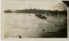
DAM NO. 5 HYDRO STATION WITH WATER STILL RISING
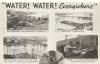
THE ORDINARILY WELL BEHAVED POTOMAC GOES ON A RAMPAGE
ONCE UPON A TIME THERE WERE BRIDGES ACROSS THE POTOMAC & SHENANDOAH AT HARPERS FERRY
GREENSPRING REALLY KNEW HIGH WATER
WHEN WATER REACHED THE TIE TREATING PLANT OF THE B & O AT GREENSPRING
AFTER THE RIVER FINISHED WITH THE CACAPON HYDRO STATION
B &O YARDS &-HIGHWAY BRIDGE BRUNSWICK
CENTER ST CUMBERLAND
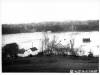
THE WATER GOES 'ROUND AND 'ROUND CUMBERLAND
Dam No. 4 received serious damage during the flood. Earlier on February 27 an ice drift had carried away a section of the dam near the Maryland abutment. The March flood widened the break, and when the water subsided it was found that the gap started at a point about 45 feet from the Maryland abutment and averaged 55 feet in width. The guard bank at the dam was little damaged, but the cross bank at the nearby stop lock was more seriously affected. Both approaches to Guard Lock No. 4 were destroyed. The lockhouse at Lock No. 41, which had withstood the 1889 freshet, was swept away.
Bridges at Williamsport, Maryland
Kelly's Studio and Camera Shop, Hagerstown Md.
3-19-1936
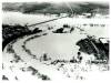
Made with Fairchild Aerial Camera
A-3
The Potomac Edison power plant was forced to shut down and the town was plunged into darkness. Pictures of the 1936 flood show the river up to the Route 11 bridge, covering the River Bottom and reaching to the base of the Bollman Bridge (West Salisbury Street, entrance to River Bottom). This photograph shows the power plant, now the R. Paul Smith Power Station, surrounded by the waters of the Potomac River.