
Maps

Washington County, 1877

Media Items
About
Body

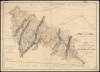
Outline Plan of Washington County, Maryland

Scale 3 miles to an inch.

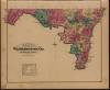
Click on the link to a larger map of each of the districts in Washington County that the canal passes through: C&O Canal Maps and then click on a district to view locations along the canal.

To see all of the districts visit our collection on Digital Whilbr: Washington County Atlas 1877

Proposed route of Canal, 1826 (between Washington & Pittsburg)

Media Items
About
Body

MAP of the country between WASHINGTON & PITTSBURG refering to the contemplated CHESAPEAKE & OHIO CANAL 
and its GENERAL ROUTE AND PROFILE OCTOBER 1826 

Reduced from the General Map annexed to the Report upon the Contemplated Canal and drawn by 
Lieut. Farley, USA. 

Etched by Wm. Harrison, Georgetown, D.C. 
Lettered by D.R. Harrison

Click image to Zoom in on clearer map.