
Washington County Maryland--History

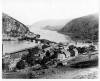
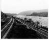
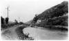
Harpers Ferry Lock and Feeder canal

Media Items
About
Body

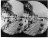
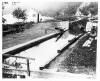
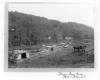
A C&O Canal freight boat is tied up in the Inlet Lock 3 that lets water into the inlet channel from behind Dam 3 located one and a half miles above Harpers Ferry. The inlet channel flows into the main stem of the canal and a bridge that carries the towpath over the inlet channel can be seen in the picture. Locks 35 and 36 are upstream from where the inlet channel meets the canal. As canal freighters required mules to pull them, they could not themselves operate in the river except where there were tug boats to tow them as at Georgetown.

Harpers Ferry

Media Items
About
Body

Photograph of lower town Harpers Ferry and the convergence of the Potomac and Shenandoah Rivers. The intersection of the bridges and railroads can be seen at The Point. The C&O Canal and Lock 33 and lock buildings are visible on the Maryland shore.

The photograph was taken prior to the B&O railroad tunnel's construction.

Lock 33

Media Items
About
Body

A berm is apparent at the upper end of this lock, resulting in the upstream gate part of the lock being raised higher than the top of the lock and the towpath going over the berm. Such a berm would have provided some protection to the lock and the canal below it when flood waters rose to the towpath level upstream from the lock. However, the berm is not high enough to provide much protection if the flood was a large one. The small white building between the towpath and the river is a lock shanty and it provided the locktender protection from the weather as well as a place to rest.

Canal & tracks near Lock 32

Media Items
About
Body

This picture was taken looking downstream at Sandy Hook. The mountain ridge to the right is Short Hill Mountain in Virginia. The road on the left leads from Weverton to Harpers Ferry. To the left of the road is Maryland Heights. (The modern Route 340 bridge from Maryland to Virginia would cross through the center of the image. )